
The Atlantic Ocean has witnessed the dramatic intensification of Hurricane Erin, which rapidly escalated to a Category 5 storm – the highest classification on the Saffir-Simpson hurricane wind scale. This powerful storm, initially traversing challenging conditions, found a more conducive environment, leading to a significant surge in its strength. The rapid intensification serves as a stark reminder of the unpredictable and potentially devastating nature of these powerful weather systems.
While the sheer power of Hurricane Erin is undeniably alarming, there’s a glimmer of hope. Its projected path, while bringing it near several landmasses, suggests that catastrophic damage might be avoided. This narrow escape, however, underscores the critical importance of continuous monitoring and preparedness in the face of such unpredictable weather events.
What Happened? 📝
After several days of battling less-than-ideal conditions across the Atlantic, Hurricane Erin underwent a period of rapid intensification. This means the storm’s wind speeds increased dramatically in a short timeframe. Favorable atmospheric conditions, such as warm ocean waters and low wind shear, fueled this explosive growth.
On Saturday, the National Hurricane Center (NHC) officially classified Erin as a Category 5 hurricane. This designation is reserved for storms with sustained winds of 157 mph or higher. A US Air Force Hurricane Hunter aircraft measured sustained winds at an astonishing 160 mph, confirming the storm’s devastating potential.
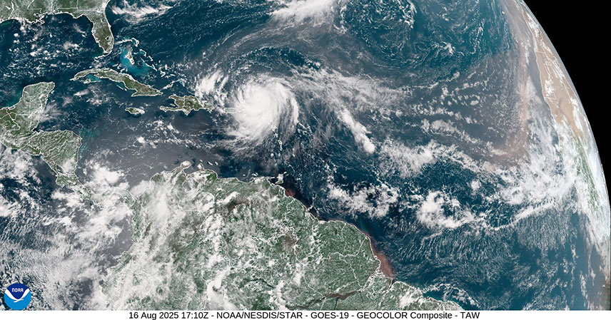
Erin’s Projected Path and Potential Impacts 🗺️
The projected path of Hurricane Erin is currently taking it on a northward trajectory. While the storm is expected to pass relatively close to several Caribbean islands, the Bahamas, and parts of the Eastern United States, the NHC forecasts it will remain far enough offshore to minimize direct landfall impacts. This doesn’t mean there will be no impact; areas in close proximity can still expect high winds, storm surge, and heavy rainfall.
Later in its projected path, Erin is expected to move between Atlantic Canada and Bermuda. While direct impact on these areas seems less likely based on current projections, residents should remain vigilant and monitor updates from official weather sources. The unpredictable nature of hurricanes means that even slight shifts in the projected path could have significant consequences.
Understanding Category 5 Hurricanes 🌪️
A Category 5 hurricane represents the most powerful classification on the Saffir-Simpson Hurricane Wind Scale. These storms are characterized by sustained winds exceeding 157 mph, capable of causing catastrophic damage. Catastrophic damage includes widespread destruction of buildings and infrastructure, significant flooding, and potentially life-threatening conditions.
The immense power of a Category 5 hurricane stems from the energy it draws from warm ocean waters. The warmer the water, the more energy the hurricane can absorb, leading to increased intensity and longevity. This is why hurricanes tend to weaken as they move over land or cooler waters.
The Importance of Hurricane Preparedness ⚠️
Hurricane Erin’s intensification highlights the crucial role of preparedness in mitigating the potential impacts of these powerful storms. Even if a hurricane doesn’t make direct landfall, its effects can still be felt over a wide area. Preparation includes having an emergency plan, stocking up on essential supplies, and staying informed about weather alerts.
Staying informed about weather updates from reputable sources, such as the National Hurricane Center (NHC), is critical. The NHC provides regular updates on storm tracks, intensity, and potential impacts, allowing individuals and communities to take appropriate precautions.
Key Takeaways 🔑
- Hurricane Erin rapidly intensified into a Category 5 hurricane with sustained winds of 160 mph.
- While the storm’s projected path suggests it will remain offshore, areas in its vicinity should still prepare for potential impacts.
- Category 5 hurricanes represent the most powerful storms, causing catastrophic damage.
- Hurricane preparedness is crucial, including having an emergency plan and staying informed about weather alerts.
Hurricane Erin serves as a potent reminder of the destructive power of nature, echoing the devastating lessons from the 20-year retrospective of Hurricane Katrina. While its projected path offers some relief, the event underscores the importance of continuous monitoring, preparedness, and the need for robust emergency response systems to protect lives and property from the unpredictable wrath of powerful hurricanes.
Source: Rapidly intensifying Hurricane Erin becomes historic storm due to strengthening